


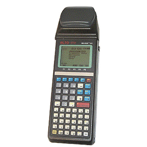
CMT MARCH-II-E L1 Hand Held GPS/GIS Data Collector
- Brand: CMT (CorvallisMicroTechnplogy Inc.). USA
- Product Code: MARCH-II-E-38-PKG
- Availability: 10 - 14 Working Days
- Rp.88,500,000
Tags: Garmin, GPS Receiver
The MARCH is a compact, cost effective, integrated GPS/GIS data collector, ideal for small data collection jobs. It has enough memory for a typical full days work. The internal 8 channel GPS receiver provides 1-5 meter accuracy with real-time or post-processing differential correction. This unit has most of the same features as the MC-GPS - it utilizes the same Field 3.8 and PC GPS Software Ver. 05, has two COM ports, and is available with a Carrier Phase option. Even though it does not have a full alpha numeric keyboard, data collection lists can still be created on the handheld using a pop-up alpha numeric menu. However for speedy creation of data collection lists it is recommended you create the lists on a PC with the PC-GPS Ver. 05 software before heading out to the field.
CMT Field Software Ver. 3.8: Collect Points, Lines Areas; Feature/Attribute/Value GIS structure;Graphic plotting.; Offset function to map hard-to-reach locations; Nested point function for tagging points while you are mapping a Line or Area Feature; Averaging function to optimize accuracy while recording static points; LLA/UTM/SPC plus user-defined coordinates; Supports 50 datums plus user-defined datums; On-board area calculation; Built-in traverse.
Using the carrier phase option, the March-II-E-CM can attain centimeter-level accuracy (2 cm + 2 ppm) without separate data collectors, antennas or poles. Uploading and processing your carrier phase data in PC-GPS is virtually the same as processing C/A code data. Behind the scenes, however, is a robust carrier phase processor (CMTCM) that will provide either a FIXED solution (ambiguities fixed to integers) or FLOAT solution (ambiguities resolved to real values). The program will notify you of which type of solution was used. You may also process the same data with the standard C/A code processor in PC-GPS.
The March-II-E-CM offers the ultimate in flexibility, allowing you to do a variety of tasks. It can be used to record 1 -5 meter data in addition to 2 cm + 2 ppm data. For example, if you have a job that requires 2 cm + 2 ppm accuracy on the property corners but only requires 1-5 meter accuracy on the streams running through the property, the March-II-E would be the perfect tool. It can perform both tasks in the field without skipping a beat. In the past, you would have needed two different types of GPS receivers to do this job.
The MARCH-II-E package includes CMT's PC-GPS software for comprehensive GPS project management and mapping. PC-GPS 3.8 provides functions for Mapping, Mission Planning, Batch Differential Correction, Static Point "Spread" analysis and Job Editing. The software also supports GIS layering, raster images (i.e. DOQs, DRGs, aerial photographs, satellite imagery), multimedia objects (OLE 2.0) and Microsoft® ODBC
System Features:
- 8-channel L1 frequency
- Full wavelength carrier phase on L1
- Carrier-phase smoothing
- Up to 1 Hz position update rate
- Up to 1 Hz code & phase measurements
- 1 PPS timing signal
Data Collector Features:
- Waterproof (submersible)
- Operating temperature: -20°C to 54°C
- Audible beeper
- 8 line x 21 character backlit display
- 2 MB RAM, 512K Flash EPROM
- 7.9" (20 cm) x 3.9" (9.9 cm) x 3.0" (7.62 cm)
- Fully integrated GPS receiver, antenna and data collector in one hand-held unit
- 14-key keyboard including 5 function keys
- External antenna port
- Up to 5 hrs. on internal, rechargeable battery
- Field-replaceable rechargeable battery
CMT Field Software v3.8
- Collect Points, Lines Areas
- Feature/Attribute/Value GIS structure
- Graphic plotting.
- Traversing keyboard data entry to allow you to continue mapping when GPS is obstructed
- Offset function to map hard-to-reach locations.
- Nested point function for tagging points while you are mapping a Line or Area Feature.
- Averaging function to optimize accuracy while recording static points.
- LLA/UTM/SPC plus user-defined coordinates.
- Supports 50 datums plus user-defined datums.
- Provides area calculation in the field
- Interfaces to laser rangefinders, barcode readers and various NMEA devices
- Canyon, Blockage and Clear modes for optimal tracking performance
What's in the Box:
- (1) Field Software Version 3.8
- (1) PC-GPS Version 0.9
- (1) 2 Megabyte RAMDISK
- (1) PC Transfer Cable
- (1) Megabyte RAMDISK
- (1) C/A Code Differential
- (1) Carrier Phase Differential
- (1) Spare MARCH Battery
- (1) Spare MARCH Battery Recharger
- (1) External Antenna, 2M Cable, Range Pole and Pole Holder
Brochure/Datasheet
Instruction manual
Catatan: Harga tidak mengikat, sewaktu waktu bisa berubah tanpa pemberitahuan dahulu

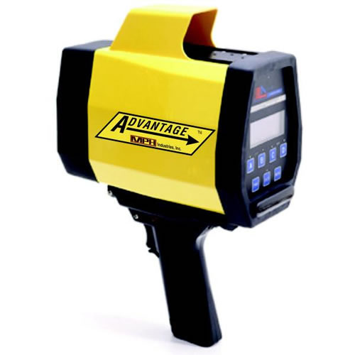
An excellent unit for precision agriculture, hydrographic surveys, and utility mapping.Signal inaccu...
Rp.101,700,000

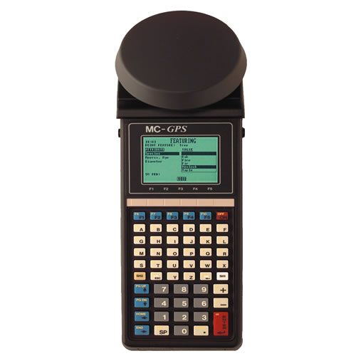
The choice for foresters. Works well under tree canopy. Includes the industry's only built-in TRAVE...
Rp.72,500,000
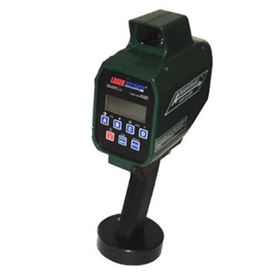
![Laser Atlanta 3RC1 Advantage R Range Finder [DISCONTINUED]](https://www.gpsforestry-suppliers.com/image/cache/catalog/product/Laser_Atlanta_3RC1-1-900x900.jpg)
Laser Atlanta 3RC1 Advantage R Range Finder [DISCONTINUED] SEE KUSTOM SIGNALS CONTOUR SERIES&nb...
Rp.65,450,000
The Laser Atlanta Advantage S Range Finder 3SC1 with Bluetooth ARSO is an excellent long range ...
Rp.53,350,000